Best Hiking Trails in Big Bear Lake, CA
Pacific Crest Trail - a 2600 mile trail from Mexico to Canada passes through Big Bear Valley
|
|
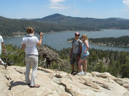
Cougar Crest Trail (pictured above) |
SUMMARY
This is one of the top 2 hiking trails in Big Bear Lake. The view above should be plenty motivating. You can see the peaks of Mt. Baldy, Gray's Peak, Butler Peak Fire lookout, Delamar Mountain, Bertha Peak, Sugarloaf Mountain, San Gorgonio range, Snow Summit, Bear Mountain, Snow Valley, Big Bear Dam, and much more. The trail to this picturesque lookout is about 2 miles long. Its never too steep and well maintained. You will feel the effects of high altitude if you aren't accustomed to hiking at elevation. But this trail can be done by almost everyone.
DETAILS
Cougar Crest - Big Bear Lake, CA
Elevation: Start 6696ft - End 7500ft ~ 800ft
Distance: 2.2 miles each way - out and back
Cougar Crest Trail is about 2.2 miles up and you can't get lost. There is a well marked parking lot at the trail head.
The trail winds up and at around the 2.1 mile mark you will have incredible views of the whole valley and lake.
The trail keeps going over and behind the ridge and turns into a road that goes up to Bertha Peak.
The valley to the North is Holcomb Valley. There is lots of Gold Mining History in Holcomb Valley and you can drive through it on the Gold Fever Trail (a self guided driving tour)
You can see Bertha Peak from various spots along Cougar Crest Trail. (Its the peak to the NE with the radio towers on it)
BONUS: You won't often meet mountain bikes on this trail.
|
|
Castle Rock Trail |
SUMMARY
This is the other top hiking trail in Big Bear Lake. 360 degree view from the top! Best photo spot over the lake. This trail is very strenuous for half a mile. Then it gets easier. If you are good at climbing rocks you can make it to the top. But there are also smaller rocks below the top of Castle Rock where you can relax and enjoy the view.
DETAILS
Castle Rock Trail - Big Bear Lake, CA ( GPS MAP Pictures )
Elevation Start 6890ft, End 7326ft
Distance: Just less than a mile from 18 Trailhead to Castle Rock
This is a great trail for everyone. The payoff is incredible views of the lake and valley. This trail is quite steep, but since its only a mile, almost everyone can do it with a few breaks to gasp for more of our thin mountain air. My GPS route below goes from trail head to trail head with Castle Rock in the middle. This trail should not be attempted when there is snow on the ground without crampons or snowshoes as sections are steep, slippery and treacherous.
| ___castle_rock_trail.kmz |